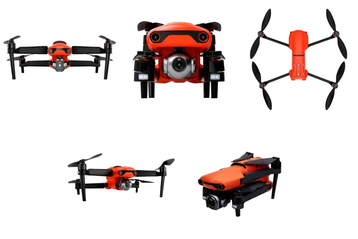
The Autel EVO II Pro V2 is a professional-grade unmanned aerial system (UAS) designed for high-resolution aerial imaging, inspection, and environmental monitoring applications.
It integrates a 1-inch CMOS imaging sensor, advanced obstacle avoidance, and extended flight endurance, enabling the acquisition of high-quality visual datasets in a compact and portable platform. While it does not include RTK positioning, it provides strong imaging performance suitable for mapping support, inspection, and documentation tasks.
The EVO II Pro V2 is optimised for high-resolution visual data capture, combining 6K video capability with intelligent flight control and multi-directional sensing. It is particularly suited for inspection, monitoring, and mid-level mapping workflows, where high image quality is required but survey-grade geospatial accuracy is not essential.
Key Highlights
- 1-inch CMOS camera (20 MP) with adjustable aperture (f/2.8–f/11)
- 6K ultra-high-definition video (5472 × 3076) with HDR support
- Extended flight time of up to ~40 minutes
- Omnidirectional obstacle avoidance system with multi-sensor input
- Long-range transmission (~9–10 km under optimal conditions)
- Advanced AI-based tracking and automated flight modes
- High wind resistance (~12 m/s) for reliable field deployment
- Multi-GNSS support for standard positioning
- RAW (12-bit DNG) image capture for high-quality post-processing
- Foldable and portable design for rapid deployment
Typical Applications
- Aerial imaging and inspection
- ESIA site reconnaissance and visual documentation
- Infrastructure inspection (pipelines, roads, facilities)
- Construction monitoring and progress tracking
- Agricultural and land-use surveys
- Disaster assessment and situational mapping
Industries and Use Cases
- Environmental Consulting – site documentation and mapping support
- Oil & Gas – infrastructure and corridor inspection
- Construction – site monitoring and visual reporting
- Agriculture – land and crop monitoring
- Utilities – inspection of assets and facilities
- Urban Planning – visual data acquisition for GIS workflows
Integrated Sensor Architecture Summary
The Autel EVO II Pro V2 integrates the following core systems:
- High-resolution imaging sensor (1-inch CMOS, 20 MP)
- Multi-directional vision-based obstacle avoidance system
- Ultrasonic proximity sensors
- Multi-GNSS positioning system
- Dual IMU and compass for flight stability
- Barometric altitude sensor
- AI-based tracking and navigation system
This integrated architecture enables stable flight performance and reliable visual data acquisition across varied operating environments.
Key Components & Sensor Specifications
| Component | Specification |
|---|---|
| Imaging System (Primary Data Acquisition Sensor) | |
| Camera Sensor | 1-inch CMOS sensor |
| Resolution | 20 MP (5472 × 3648) |
| Lens | Equivalent focal length ~28.6 mm |
| Aperture | Adjustable f/2.8 – f/11 |
| Field of View (FOV) | ~82° |
| ISO Range | 100 – 12,800 (photo) |
| Zoom | Up to 8× digital (≈3× lossless) |
| Video Capability | Up to 6K (5472 × 3076) |
| Image Formats | JPEG, RAW (12-bit DNG) |
| Obstacle Avoidance & Vision Sensor System (Core Safety Sensors) | |
| Total Sensor System | ~19 sensors integrated |
| Visual Sensors | 12 computer vision sensors (omnidirectional) |
| Coverage | Forward, backward, lateral, upward, downward |
| Ultrasonic Sensors | Dual sonar sensors for proximity detection |
| Function | 3D environment mapping, obstacle detection, collision avoidance |
| Capability | Real-time path planning and autonomous navigation |
| Tracking System | AI-based tracking of up to 64 objects simultaneously |
| Navigation & Positioning Sensors | |
| GNSS Systems | GPS, GLONASS, Galileo, BeiDou |
| Positioning Accuracy | Horizontal: ~±1.5 m (GPS); improved with vision sensors |
| Visual Positioning System (VPS) | High-precision low-altitude stabilization |
| Function | Flight navigation, hovering stability, geolocation tagging |
| Flight Stability & Motion Sensors (Core UAV Control System) | |
| IMU (Inertial Measurement Unit) | Dual IMUs (redundancy) |
| Compass | Dual compass system |
| Barometer | Altitude measurement and stabilization |
| Ultrasonic Sensors | Low-altitude positioning support |
| Function | Flight stabilization, orientation, motion tracking |
| Intelligent Processing & AI Sensors | |
| Onboard Processing | Dual-core processor with machine learning capability |
| AI Capabilities | Object detection, tracking, trajectory prediction |
| Dynamic Tracking | Predictive tracking of moving targets |
| Function | Autonomous flight, inspection automation, object recognition |
| Communication & Data Transmission System | |
| Transmission System | Dual-band (2.4 GHz / 5.8 GHz) |
| Max Range | Up to ~9–10 km (FCC conditions) |
| Live Feed | HD real-time video transmission |
| Function | Command, control, telemetry, and data transfer |
Compare with (i) DJI Mavic Air 2, (ii) DJI Mavic 3 Enterprise RTK and (iii) DJI Matrice 350 RTK (L1 LiDAR) : (see table)
| Parameter | DJI Mavic Air 2 | DJI Mavic 3 Enterprise RTK | Autel EVO II Pro V2 | DJI Matrice 350 RTK (L1 LiDAR) |
|---|---|---|---|---|
| System Class | Compact prosumer UAV | Compact enterprise mapping UAV | Professional aerial imaging UAV | Enterprise LiDAR mapping UAV |
| Primary Use | Reconnaissance & visual documentation | Survey-grade mapping & inspection | High-resolution imaging & inspection | LiDAR-based 3D mapping & terrain modelling |
| Positioning System | Standard GNSS | RTK GNSS (cm-level accuracy) | Standard GNSS (no RTK) | RTK GNSS (cm-level accuracy) |
| Mapping Capability | ⚠️ Basic mapping only | ✅ Survey-grade photogrammetry | ⚠️ Mapping support (non-survey grade) | ✅ True 3D LiDAR mapping |
| Primary Sensor | 1/2″ CMOS, 48 MP | 4/3″ CMOS, 20 MP (mechanical shutter) | 1″ CMOS, 20 MP | LiDAR + RGB camera |
| Shutter Type | Electronic | Mechanical (mapping-optimised) | Electronic | Mechanical (RGB) + LiDAR scanning |
| LiDAR Capability | ❌ Not available | ❌ Not available | ❌ Not available | ✅ Full LiDAR system |
| Point Cloud Output | ❌ No | ❌ No | ❌ No | ✅ High-density (up to ~480k pts/sec) |
| Camera Capability | 48 MP photo / 4K video | 20 MP + zoom camera | 20 MP + 6K video | ~20 MP RGB mapping camera |
| Zoom Capability | Digital only | Up to ~56× hybrid | Digital (~8×) | Not primary function |
| Flight Time | ~34 minutes | ~45 minutes | ~40 minutes | ~55 minutes |
| Coverage Efficiency | Low–moderate | High | Moderate | Very high |
| Obstacle Avoidance | Forward / backward / downward | Omnidirectional | Omnidirectional | Omnidirectional + optional radar |
| Transmission System | OcuSync 2.0 (~10 km) | DJI O3 Enterprise (~15 km) | Dual-band (~9–10 km) | DJI O3 Enterprise (~15–20 km) |
| Payload Capacity | Fixed camera | Fixed camera system | Fixed camera system | ~2.7 kg (multi-sensor capable) |
| Operational Complexity | Low | Medium | Low–medium | High |
| Portability | Very high (ultra-compact) | High | High | Moderate |
| Accuracy Level | Metre-level (GNSS) | Centimetre-level (RTK) | Metre-level (GNSS) | Centimetre-level (RTK LiDAR) |
| Best Use Case | Quick reconnaissance & site documentation | Mapping, surveying, inspection | Visual inspection & high-quality imaging | LiDAR mapping, terrain modelling |
| Performance in Vegetated Areas | Limited | Limited | Limited | ✅ Strong (LiDAR penetration) |
What UAV systems do you deploy?
- DJI Mavic Air 2 (rapid reconnaissance)
- DJI Mavic 3 Enterprise RTK (survey-grade mapping)
- Autel EVO II Pro V2 (high-quality imaging)
- DJI Matrice 350 RTK + Zenmuse L1 LiDAR (advanced terrain/3D mapping)
Which UAV should I use for my project?
Project Need → Recommended UAV
- Quick site inspection / visuals → Mavic Air 2
- High-quality imagery / inspection → Autel EVO II Pro V2
- Survey-grade mapping → Mavic 3 Enterprise RTK
- Dense vegetation / terrain modelling → Matrice 350 RTK (LiDAR)
Is the Mavic Air 2 suitable for mapping?
It supports basic photogrammetry but is not survey-grade due to lack of RTK. Best for visuals and preliminary mapping.
What makes the Mavic 3 Enterprise RTK different?
RTK delivers centimetre-level accuracy, enabling:
- Orthomosaics
- Photogrammetry
- High-accuracy corridor/infrastructure mapping
What makes the Matrice 350 RTK with L1 LiDAR unique?
LiDAR enables:
- True 3D terrain mapping
- High-density point clouds
- Vegetation canopy penetration (better than photogrammetry in dense cover)
Can EcoPro provide UAV data processing and analysis?
Yes. We provide:
- Photogrammetry processing
- LiDAR processing
- GIS integration
- Technical reporting
Are your UAV operations compliant with regulations?
Yes. EcoPro operations follow:
- Nigerian aviation requirements (project dependent)
- International safety and best practice procedures
- Client/project-specific compliance rules
Can EcoPro deploy multiple UAV systems on one project?
Yes. We deploy multi-UAV solutions based on scope, terrain, timeline, and required accuracy.