
Unmanned Aerial Vehicles (Drones)

DJI Matrice 350 RTK (L1 Sensor)

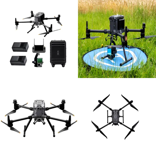
The DJI Matrice 350 RTK equipped with the Zenmuse L1 payload is an enterprise-grade UAV-based LiDAR system designed for high-precision 3D mapping, terrain modelling, and geospatial data acquisition. It integrates LiDAR scanning, high-accuracy RTK GNSS positioning, inertial measurement, and an RGB mapping camera into a single platform, enabling the capture of dense, georeferenced point cloud datasets with centimetre-level accuracy.

Autel EVO II Pro V2 (UAV System)

The Autel EVO II Pro V2 is a professional-grade unmanned aerial system (UAS) designed for high-resolution aerial imaging, inspection, and environmental monitoring applications. It integrates a 1-inch CMOS imaging sensor, advanced obstacle avoidance, and extended flight endurance, enabling the acquisition of high-quality visual datasets in a compact and portable platform. While it does not include RTK positioning, it provides strong imaging performance suitable for mapping support, inspection, and documentation tasks.

DJI Mavic 3 Enterprise RTK (UAV System)

The DJI Mavic 3 Enterprise RTK is a compact unmanned aerial system designed for precision mapping, surveying, and inspection applications. It integrates RTK-enabled GNSS positioning, a mechanical shutter camera, and multi-directional obstacle sensing to deliver high-accuracy geospatial data acquisition. The system combines long flight endurance, high-resolution photogrammetry capability, and intelligent mission planning, making it suitable for rapid deployment across large and complex project environments.

DJI Mavic Air 2 (UAV System)

The DJI Mavic Air 2 is a compact unmanned aerial system (UAS) designed for aerial imaging, site reconnaissance, and general-purpose environmental monitoring. It integrates a high-resolution camera, intelligent flight systems, and extended flight time within a portable platform suitable for rapid deployment.