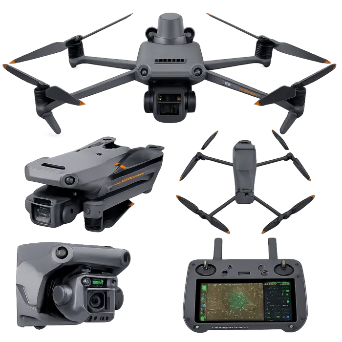
The DJI Mavic 3 Enterprise RTK is a compact unmanned aerial system designed for precision mapping, surveying, and inspection applications. It integrates RTK-enabled GNSS positioning, a mechanical shutter camera, and multi-directional obstacle sensing to deliver high-accuracy geospatial data acquisition.
The system combines long flight endurance, high-resolution photogrammetry capability, and intelligent mission planning, making it suitable for rapid deployment across large and complex project environments.
The DJI Mavic 3 Enterprise RTK integrates advanced imaging, RTK GNSS positioning, and multi-directional sensing technologies into a compact UAV platform, enabling high-precision geospatial data acquisition, safe autonomous navigation, and reliable inspection capability. Its sensor suite supports the generation of accurate, defensible spatial datasets for ESIA baseline mapping, infrastructure monitoring, and GIS-driven analysis in line with international best practice.
Key Highlights
- RTK positioning module: Provides centimeter-level accuracy for mapping and surveying
- 4/3 CMOS 20 MP camera with mechanical shutter: Eliminates motion blur for accurate mapping outputs
- 56× hybrid zoom capability: Enables detailed inspection from safe distances
- Extended flight time: Up to ~45 minutes per flight
- High-efficiency mapping: Capable of covering large areas (≈2 km² per flight depending on conditions)
- Omnidirectional obstacle avoidance: Enhances flight safety in complex environments
- Multi-GNSS support: GPS, Galileo, BeiDou, and GLONASS for reliable positioning
- O3 Enterprise transmission system: Long-range, stable communication link
- Portable, foldable design: Rapid deployment for field operations
- Integrated mission planning tools: Automated flight paths for mapping and inspection
Typical Applications
- Topographic and geospatial mapping (photogrammetry)
- Environmental and Social Impact Assessment (ESIA) – terrain mapping and land use analysis
- Infrastructure inspection (pipelines, power lines, roads)
- Construction monitoring and progress tracking
- Asset inspection and facility surveillance
- Disaster assessment and emergency response mapping
- Agricultural and land management surveys
Industries and Use Cases
- Environmental Consulting (ESIA/ESMP) – baseline mapping and spatial analysis
- Oil & Gas / Pipeline Projects – corridor mapping and inspection
- Construction & Infrastructure – site monitoring and volumetric analysis
- Mining & Quarrying – stockpile measurement and terrain modelling
- Utilities (Power, Water) – asset inspection and maintenance
- Urban Planning & GIS – land use mapping and spatial data generation
- Government & Emergency Services – disaster response and reconnaissance
Integrated Sensor Architecture Summary
The DJI Mavic 3 Enterprise RTK integrates:
- Photogrammetry-grade imaging sensors (20 MP CMOS + mechanical shutter)
- Inspection-grade zoom optics (56× hybrid zoom)
- Centimeter-level RTK GNSS positioning system
- Omnidirectional vision-based obstacle sensing (multi-directional cameras)
- Infrared proximity and altitude sensors
- Flight stabilization sensors (IMU, barometer, compass)
Key Components & Sensor Specifications
| Component | Specification |
|---|---|
| Imaging System (Primary Survey & Inspection Sensors) | |
| Wide-Angle Camera Sensor | 4/3″ CMOS sensor, 20 MP |
| Shutter Type | Mechanical (global shutter – eliminates motion blur) |
| Pixel Size | ~3.3 µm (enhanced low-light performance) |
| Field of View (FOV) | ~84° |
| Image Resolution | Up to 5280 × 3956 pixels |
| Capture Interval | ~0.7 seconds (high-efficiency mapping) |
| Video Capability | 4K @ 30 fps |
| Use Case | Photogrammetry, orthomosaics, terrain modelling |
| Zoom Camera (Inspection Sensor) | |
| Sensor Type | 1/2″ CMOS |
| Resolution | 12 MP |
| Zoom Capability | Up to 56× hybrid zoom |
| Equivalent Focal Length | ~162 mm |
| Use Case | Remote inspection, surveillance, asset monitoring |
| RTK Positioning System (Geospatial Sensor Suite) | |
| RTK Module Type | Real-Time Kinematic GNSS module |
| Positioning Accuracy (RTK Fix) | Horizontal: 1 cm + 1 ppm; Vertical: 1.5 cm + 1 ppm |
| Supported GNSS Systems | GPS, GLONASS, Galileo, BeiDou |
| Function | High-precision georeferencing for mapping and surveying |
| Output | Centimeter-level positioning (eliminates need for dense GCPs) |
| Navigation & Obstacle Avoidance Sensors | |
| Sensor Type | Specification |
| Technology | Binocular vision sensors (multi-directional) |
| Coverage | Forward, backward, lateral, upward, downward |
| Forward Detection Range | 0.5 – 200 m |
| Lateral Detection Range | 0.5 – 25 m |
| Downward Detection Range | 0.3 – 18 m |
| Field of View | Up to 160° depending on direction |
| Function | Collision avoidance and autonomous navigation |
| Infrared (IR) Sensor | |
| Type | Downward infrared sensing |
| Function | Altitude stabilization and obstacle detection in low-light conditions |
| Flight & Motion Sensors (Core UAV Stability System) | |
| IMU (Inertial Measurement Unit) | Multi-axis gyroscope and accelerometer |
| Compass | Dual redundancy compass system |
| Barometer | Altitude measurement and stabilization |
| GNSS Receiver | Multi-constellation satellite positioning |
| Function | Flight stability, navigation, and positioning fusion |
| Transmission & Communication System | |
| Transmission System | DJI O3 Enterprise |
| Max Range | Up to ~15 km (FCC conditions) |
| Live Feed | 1080p HD real-time transmission |
| Function | Reliable command and control, data transmission |
| Auxiliary Payload Sensors & Components | |
| Speaker (Optional) | 3 W output, up to 110 dB @ 1 m (DJI) |
| RTK Base Station Compatibility | Yes (D-RTK 2 or NTRIP) |
| Controller Sensor Suite | High-brightness display, microphone, GPS |
Compare with (i) DJI Mavic Air 2, (ii) Autel EVO II Pro V2 and (iii) DJI Matrice 350 RTK (L1 LiDAR) :(see table)
| Parameter | DJI Mavic Air 2 | DJI Mavic 3 Enterprise RTK | Autel EVO II Pro V2 | DJI Matrice 350 RTK (L1 LiDAR) |
|---|---|---|---|---|
| System Class | Compact prosumer UAV | Compact enterprise mapping UAV | Professional aerial imaging UAV | Enterprise LiDAR mapping UAV |
| Primary Use | Reconnaissance & visual documentation | Survey-grade mapping & inspection | High-resolution imaging & inspection | LiDAR-based 3D mapping & terrain modelling |
| Positioning System | Standard GNSS | RTK GNSS (cm-level accuracy) | Standard GNSS (no RTK) | RTK GNSS (cm-level accuracy) |
| Mapping Capability | ⚠️ Basic mapping only | ✅ Survey-grade photogrammetry | ⚠️ Mapping support (non-survey grade) | ✅ True 3D LiDAR mapping |
| Primary Sensor | 1/2″ CMOS, 48 MP | 4/3″ CMOS, 20 MP (mechanical shutter) | 1″ CMOS, 20 MP | LiDAR + RGB camera |
| Shutter Type | Electronic | Mechanical (mapping-optimised) | Electronic | Mechanical (RGB) + LiDAR scanning |
| LiDAR Capability | ❌ Not available | ❌ Not available | ❌ Not available | ✅ Full LiDAR system |
| Point Cloud Output | ❌ No | ❌ No | ❌ No | ✅ High-density (up to ~480k pts/sec) |
| Camera Capability | 48 MP photo / 4K video | 20 MP + zoom camera | 20 MP + 6K video | ~20 MP RGB mapping camera |
| Zoom Capability | Digital only | Up to ~56× hybrid | Digital (~8×) | Not primary function |
| Flight Time | ~34 minutes | ~45 minutes | ~40 minutes | ~55 minutes |
| Coverage Efficiency | Low–moderate | High | Moderate | Very high |
| Obstacle Avoidance | Forward / backward / downward | Omnidirectional | Omnidirectional | Omnidirectional + optional radar |
| Transmission System | OcuSync 2.0 (~10 km) | DJI O3 Enterprise (~15 km) | Dual-band (~9–10 km) | DJI O3 Enterprise (~15–20 km) |
| Payload Capacity | Fixed camera | Fixed camera system | Fixed camera system | ~2.7 kg (multi-sensor capable) |
| Operational Complexity | Low | Medium | Low–medium | High |
| Portability | Very high (ultra-compact) | High | High | Moderate |
| Accuracy Level | Metre-level (GNSS) | Centimetre-level (RTK) | Metre-level (GNSS) | Centimetre-level (RTK LiDAR) |
| Best Use Case | Quick reconnaissance & site documentation | Mapping, surveying, inspection | Visual inspection & high-quality imaging | LiDAR mapping, terrain modelling |
| Performance in Vegetated Areas | Limited | Limited | Limited | ✅ Strong (LiDAR penetration) |
What UAV systems do you deploy?
- DJI Mavic Air 2 (rapid reconnaissance)
- DJI Mavic 3 Enterprise RTK (survey-grade mapping)
- Autel EVO II Pro V2 (high-quality imaging)
- DJI Matrice 350 RTK + Zenmuse L1 LiDAR (advanced terrain/3D mapping)
Which UAV should I use for my project?
Project Need → Recommended UAV
- Quick site inspection / visuals → Mavic Air 2
- High-quality imagery / inspection → Autel EVO II Pro V2
- Survey-grade mapping → Mavic 3 Enterprise RTK
- Dense vegetation / terrain modelling → Matrice 350 RTK (LiDAR)
Is the Mavic Air 2 suitable for mapping?
It supports basic photogrammetry but is not survey-grade due to lack of RTK. Best for visuals and preliminary mapping.
What makes the Mavic 3 Enterprise RTK different?
RTK delivers centimetre-level accuracy, enabling:
- Orthomosaics
- Photogrammetry
- High-accuracy corridor/infrastructure mapping
What makes the Matrice 350 RTK with L1 LiDAR unique?
LiDAR enables:
- True 3D terrain mapping
- High-density point clouds
- Vegetation canopy penetration (better than photogrammetry in dense cover)
Can EcoPro provide UAV data processing and analysis?
Yes. We provide:
- Photogrammetry processing
- LiDAR processing
- GIS integration
- Technical reporting
Are your UAV operations compliant with regulations?
Yes. EcoPro operations follow:
- Nigerian aviation requirements (project dependent)
- International safety and best practice procedures
- Client/project-specific compliance rules
Can EcoPro deploy multiple UAV systems on one project?
Yes. We deploy multi-UAV solutions based on scope, terrain, timeline, and required accuracy.